


The Old Country
Land Records
and the
Survey System
Mixson Land
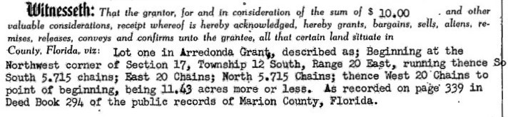
And there it was, a description of the old Mixson farmstead that had been in the family for five generations. I had been searching for land and deed records on Marion County’s land deeds database when I found it. I had been looking for early information on the old Mixson farmstead for stories I was writing. I read the description, “Lot one in Arrendondo Grant”, what was the Arrendondo Grant? I wondered. The land was described as being in some section, township, and range with chains running the cardinal directions of North, South, East and West. I wasn’t sure what it all meant so off I went on an exploration into the history of land acquisition in Florida.
Arrendondo Grant
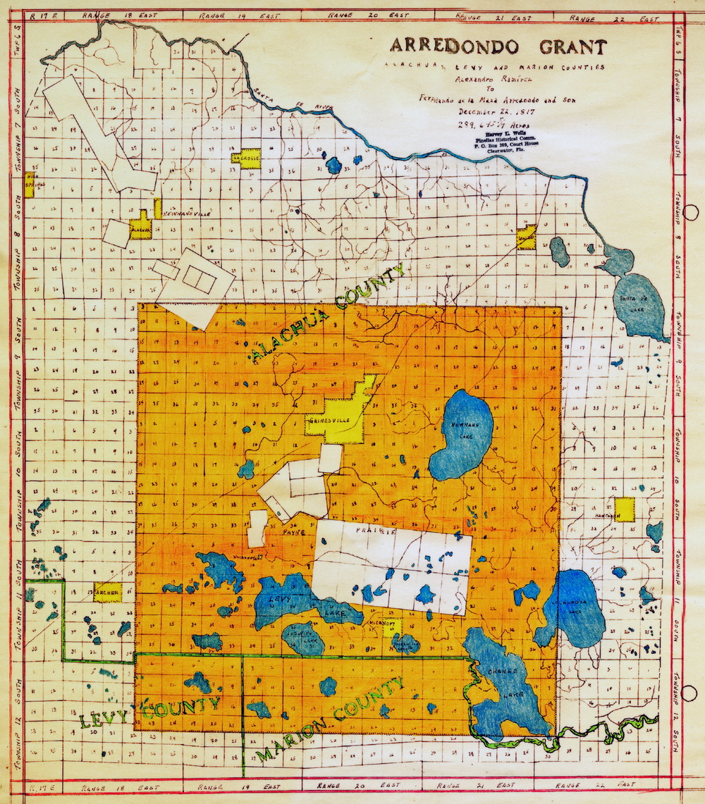
Map showing the Arrendondo Grant in Alachua County
showing Township, Range, Section grid.
Click for larger view
A quick search on the Internet I quickly find that the Arrendondo Grant is a tract of land in north central Florida that goes back to the Spanish in colonial times and encompassed Gainesville, where I grew up, Micanopy, and apparently, the old Mixson farmstead. On my birthday, December 22nd, but in 1817, (I was born 135 years later), the King of Spain granted to Don Fernando de Maza Arredondo a tract of land containing 289,645 and five-sevenths acres located “Four Leagues of Land to each Wind” from “the Sink” the sink being the Alachua Sink that drains Paynes Prairie. This was just two years before Spain ceded Florida to the United States, which made the “last minute” grant of questionable validity and was challenged in court. It wasn’t until 1832 that that the case was decided by the U.S. Supreme Court that affirmed Arrendondo’s ownership. As it turns out, Charles Jones Mixson first bought land in the area in 1851.
Ok, that explained the Arrendondo Grant part but what was the Township, Range, and Section part.
Rectangular Survey System
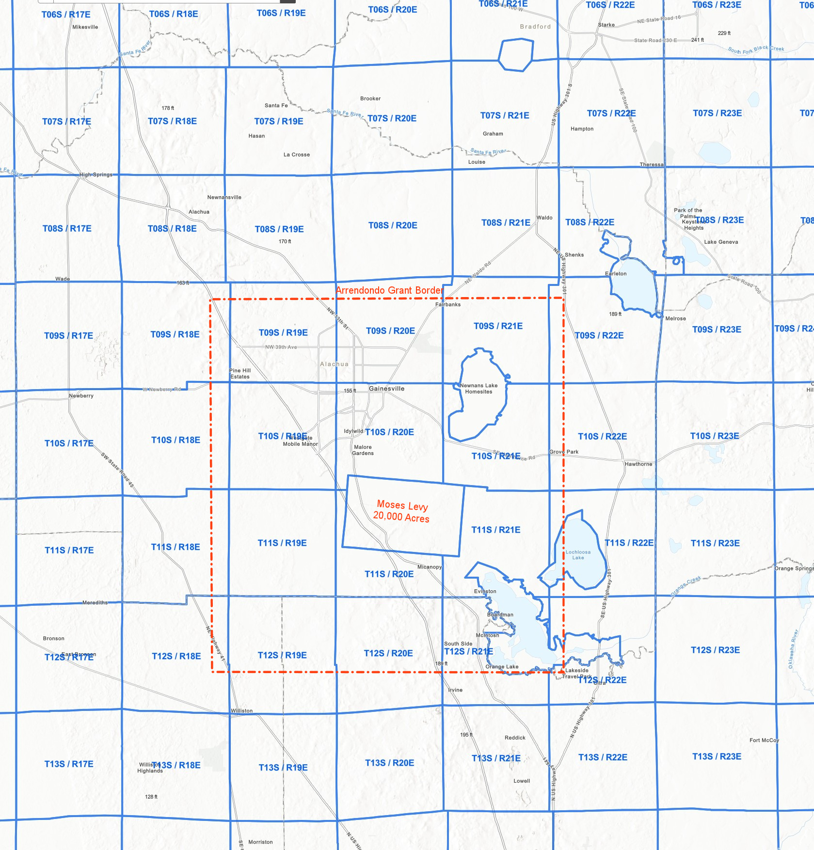
In 1785 the U.S. Government passed the Land Ordinance Act authorizing the Treasury Department to survey and sell public land. To facilitate this, the rectangular survey system was adopted so lands could be identified for legal description. The survey system divided the land into a rectangular grid with the coordinate of each rectangle in the grid identified by a row and column within the grid. The column, or North-South, number was called the Township while the row, or East-West, number was called the Range. Each rectangle was further divided into 36 equal smaller squares which were called Sections. An example of a plat of land would be, Township 7 South, Range 18 East, Section 16. Although this would be the logical order, in Deeds and records the section is written first for the example would be, Section 16 in Township 7, Range 18 East, or abbreviated: S16-T07-R18E. See illustrations below.
Map showing Townships 06-13 - Ranges 17-23
Arrendondo Grant border in red
Florida Survey
When the Land Ordinance Act was passed in 1785 Florida was under Spanish control and not part of the U.S. so it was not surveyed until after Florida became a U.S. Territory in 1824 and this first survey only included the panhandle and north Florida. Survey of the remainder of Florida would not be completed until 1860. The original 1824 survey notes and plats have been preserved and made available online by the Florida Department of Environmental Protection. Later the records and system were transferred to the Bureau of Land Management. Searchable, interactive maps of the survey system by Township-Range-Section can be found at Bureau of Land Management and the Florida Land Boundary Information System.
Glossary
-
BLM – Bureau of Land Management (US)
Search
About Land Patents -
LABINS – Florida Land Boundary Information System
Search Early Records (1824) by Township-Range -
Land Patents When the public lands were sold, land "patents" were issued. Patents are deeds transferring land ownership from the Federal government to individuals.
-
Land Offices were established in the district handling the land transactions. They would frequently move and close within the States as the land within their jurisdiction began dwindling.
-
Land Survey System Using the rectangular system of survey, lands were divided into Townships containing 6 square miles. Each Township was subdivided into 36 Sections, each containing approximately 640 acres. Each Section was further subdivided into halves and quarters, repeatedly, until the parcel of land was accurately described.
-
Township identifies a major subdivision of the public lands under the rectangular system of surveys. Most Townships measure approximately 6 miles on each side and contain approximately 23,040 acres. A Township is identified by its relationship to a base line and a principal meridian. For example, "Township 5 South, Range 12 West, 5th Principal Meridian" identifies a particular township that is 5 tiers south from the base line of the 5th Principal Meridian.
-
Range is used in conjunction with the Township data field identifies a row or tier of townships lying east or west of the principal meridian and numbered successively to the east or west from the principal meridian. In the example "Township 5 South, Range 12 West," the number 12 represents the Range Number that is used to identify the township that is 12 tiers to the west of the principal meridian.
-
Section Number identifies a tract of land, usually 1 mile square, within a township. Most townships contain 36 sections. Standard sections contain 640 acres. A section number identifies each section within a township.
-
Aliquot Parts Using the rectangular system of survey, lands were divided into Townships containing 6 square miles. Each Township was subdivided into 36 Sections, each containing approximately 640 acres. Each Section was further subdivided into halves and quarters, repeatedly, until the parcel of land was accurately described. Without the use of Fractional Sections, Blocks, or Lots (in the case of uneven parcels of land), Aliquot Parts were used to represent the exact subdivision of the section of land. Halves of a Section (or subdivision thereof) are represented as N, S, E, and W (such as "the north half of section 5"). Quarters of a Section (or subdivision thereof) are represented as NW, SW, NE, and SE (such as "the northwest quarter of section 5"). Sometimes, several Aliquot Parts are required to accurately describe a parcel of land. For example, "ESW" denotes the east half of the southwest quarter containing 80 acres and "SWNENE" denotes the southwest quarter of the northeast quarter of the northeast quarter containing 10 acres. It is important to remember that the Aliquots shown in the data base (e.g., "SWNENE") usually translates into words found on the land document.
-
Size in Acres
a section contains 640 acres,
a half section contains 320 acres,
a quarter section contains 160 acres,
a half of a quarter contains 80 acres,
a quarter of a quarter contains 40 acres, etc.