


The Old Country
1842
Armed Occupation Act
The Armed Occupation Act provided grants of 160 acres of land in the prime farmland area south of a line extending westward from Palatka on the St. Johns, going about ten miles south of Newnansville and then to the Gulf coast. The line official defined as “south of the line dividing Townships numbers nine and ten, south” which passes through the center if Alachua County and what later would become the city of Gainesville.
The term “Townships” has nothing to do with towns, but rather is part of the Rectangular Survey System established in 1785 by the Treasury Department to survey and sell public land. The survey system divided the land into a rectangular grid with the coordinate of each rectangle in the grid identified by a rows called Township and columns called Range. Each square Township is further divided into 36 equal smaller squares called Sections. Thus, the location of a tract of land could be identified by its Township, Range and Section. (see diagram)
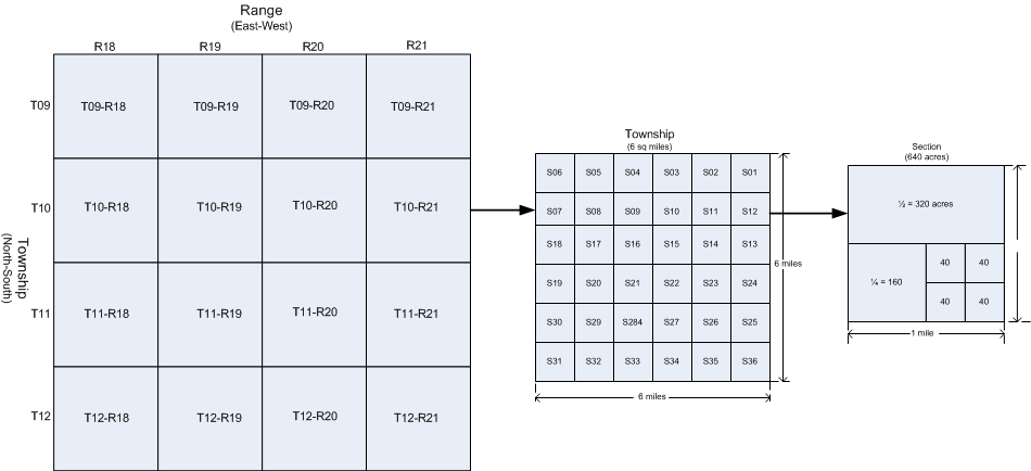
Example Township-Range-Section Illustration
From left, portion Township-Range map in Alachua County, Section order
within Township, Section division.
The “160 acres” grants in the Armed Occupation were a ¼ of a section.
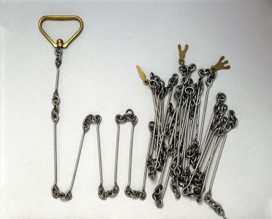
A Gunter's Chain
The Rectangular Survey System was a work in progress, and since its creation, extended from the original thirteen states westward and southward as new territories and states were formed. In 1842 with the Florida Territory only recently being acquired, the survey had only progressed southward to Township 14 which was just north of what is now Ocala and included The Old Country. (Florida, when the survey was complete, would extend south to Township 67 in Key West) Surveying took considerable time and effort, surveyors marched across the Florida landscape of marshes, swamps, lakes and rivers with heavy surveying equipment and recorded the land. The surveyors used a length measuring device called a Gunter’s Chain which was literally a The 66-foot-long length of chain is divided into 100 links, marked off into groups of 10 by brass rings. Chain was used rather than rope as rope would stretch and thus not provide consistent measurements, thus the use of chain which was quite heavy. The use of Gunter’s Chain is what gives us the land unit of the Acre which is 10 square chains.
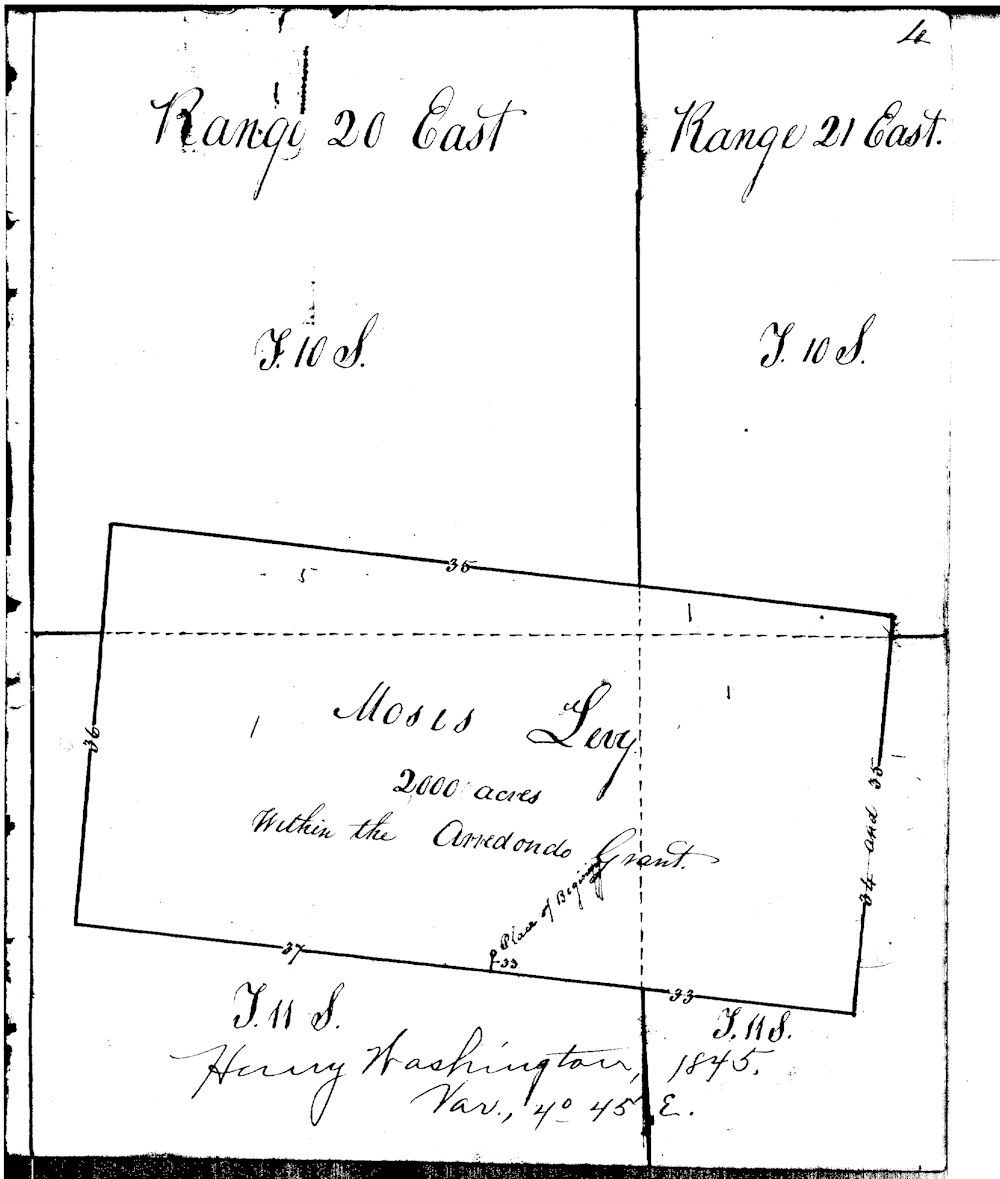
Example of orginal 1826 Land Survey of
Townships 10-11, Ranges-20-21 in Alachua county
Showing Moses Levy's 20,000 land grand in the Arrendondo Grant
The instructions for filling out a grant request specified that “In case the land has been surveyed,” the applicant should specify the Section, Township and Range number. That worked well for the limited land that had been surveyed, but the other 80%, from Ocala to Key West, the Section, Township and Range could not be specified. The instructions addressed this by specifying,
With well over half of Florida south of Ocala having not been surveyed, the instructions specified an alternative than the Township-Range-Section.
The applicant must describe, with as much quarter precision and clearness as practicable, the locality of the tract which he desires to settle upon, in reference to some natural object, such as a river, or its tributary stream, lake, pond, bayou, lagoon, or some other known and conspicuous object, such as the name of a hammock, prairie, or sink, of well known locality, or battle-ground, or other spot rendered notable either of late or remote years If such object, as herein alluded to, should not be in the immediate vicinity of the tract, it may nevertheless be useful to state the distance and bearing of the same, either from the “beginning” point of the settlement, or any other corner of the same.
This would sometimes cause issues later when such landmarks as “large oak tree” or “hammock” change over time.
The act states that any settler over the age 18, or the head of a household, could obtain 160 acres by living on it for five years, building a house and clearing five acres.
Note: Some sources say “male” instead of settler, but the actual Act says “settler”. When examining the issued grants, although the far majority are men, there are a number of grants issued to women including Eliza Attaway, Patricia Baisden, Susannah Brown, and Frances Durrance. In some cases, a mother or sister of the family would get a grant of lands adjacent to brothers such as Emma Priest and her brothers George W. Priest, Granville Priest and William Priest, all which were some of the earliest grants issued on the 6th of December, 1842.
The actual form has the instructions:
This blank must be filled up in the words of the law, according to the circumstances of the case, thus: “The head of a family,” or “a single man over eighteen years of age, able to bear arms.”
Emma Priest filled it in as “The head of a family”.
The condition “able to bear arms” was one of the key conditions of the act, since well, it was the “Armed Occupation Act”. Being armed was deemed necessary for there were still an occasional encounter with the few remaining Indians and protection was deemed necessary. With all the settlers armed I could imagine that more than a few disputes involved firearms.
Another condition was the requiring living on the land for five, clear five acres and building a house years before the land became yours. This meant speculators couldn’t just buy the land and sell it later, you actually had to live on the land. This was no easy task in such wilderness with some giving up before their five years were met. At first it seems a perfect situation with the land covered in virgin old growth pine and hardwood forests. The felling of trees not only cleared the land for farming but provided the material for building houses and barns. But this was an arduous task, large trees needed to be cut down, and the stumps removed before crops could be planted, a first priority with most the settlers being farmers who would live in some makeshift or temporary house until the land was cleared and the first crop planted. But the settlers were a determined lot and of the approximately 950 permits issued, only 24 were abandoned and annulled.
With such prime land available settlers quickly arrived, many from Georgia and South Carolina. To make it easier for settlers to buy public land or file claims, a United States General Land Office was established in Newnansville in 1842 so that settlers did not have to go all the way to St. Augustine to file claims. Close to a thousand permits were granted in the following year, with 942 being issued from the Newnansville office. A total of 151,520 acres of land was granted with about one-third of them near Fort King and Ocala.
The first grant was issued at the new Newnansville Land Office on December 15th of 1842 to Elias Hart of Alachua County. The tract was specified as:
On the West side of the Annutteliga Hammock the South West corner to be about one hundred and fifty yards South East of the Block House at the Annutteliga Settlement running thence due East on half mile thence due South half mile thence due west half mile thence north to the place of beginning.
Annutteliga Hammock, located now within the Withlacoochee State Forest between Hernando and Citrus Counties and today is a park and preserve. Fort Annutteliga was mentioned in a letter to Major Belknap in Camp McCall on March 1st 1842 near the end of the Second Seminole War. There is no trace of the referenced Annutteliga settlement.
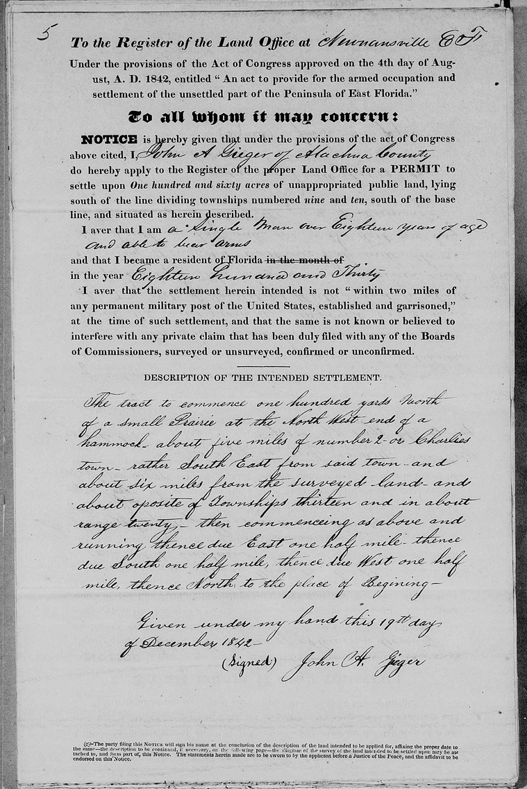
The application was quite simple, consisting of a single sheet of paper, an example follows:
TO THE REGISTER OF THE LAND OFFICE AT NEWNANSVILLE, EAST FLORIDA.
Under the provisions of the Act of Congress approved on the 4th day of August, A.D. 1842, entitled "An act to provide for the Armed Occupation and settlement of unsettled part of the Peninsula of East Florida.”
TO ALL WHO IT MAY CONCERN:
NOTICE is hereby giving that under the provisions the Act of Congress, above sided, I, John A Geiger of Alachua County, do hereby apply to the register of the proper land office for a permit to settle upon one hundred and sixty acres of unappropriated land, lying South of the line dividing townships numbered nine and ten, south of the base line and, situated as herin described.
I aver that I am a single man over eighteen years of age, able to bear arms
and that I became a resident of Florida in the month in the year Eighteen Hundred and Thirty.
I aver that the settlement herein intended is not “within two mile of any permanent military post of the United States, established and garrisoned,” at the time of such settlement, and that the saying is not known or believed to interfere with any private claim that has been duly filed with any of the Boards of Commissioners, surveyed or unsurveyed, confirmed or unconfirmed.
DESCRIPTION OF THE INTENDED SETTLEMENT:
The tract to commence one hundred yards North of a small Prairie at the North West end of a hammock about five miles of number 2-or Charlies town-rather South East from said town and about Six miles from the surveyed land and about opposite of Townships thirteen and in about range twenty – then commencing as above and running thence due East on half mile, thence due South one half mile, thence due West one half mile, thence North to the place of Beginning.
GIVEN under my hand this 19th day of December 1842.
(Signed) John A Geiger
Text in green was filled in by the applicant. Click to ee image of actual application.
The Geiger’s were some of the earliest settlers in the Old Country with John being the first. Before the Armed Occupation Act expired, Arron, Abraham, Enoch, George, Henry and Samuel Geiger would obtain land in the area.