


A New Capital
1821
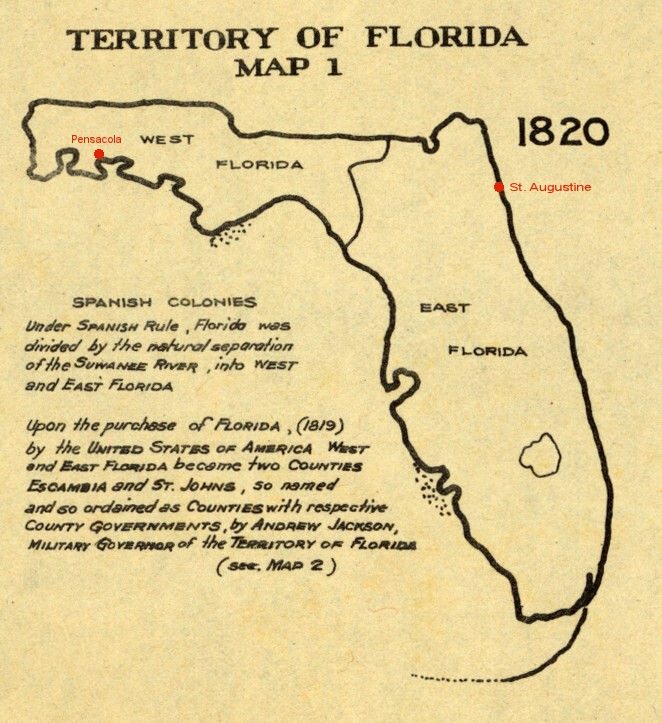
1820 map showing East and West Florida
United States formally took possession of Florida on July 17, 1821 with Andrew Jackson being appointed as its first Governor. Upon the transfer to the United States, many Spanish loyalist and free Negros fled to Cuba leaving most of Florida to the native Indians. This was the second time the Spanish fled Florida, the first being after Spain ceded Florida to the British in 1763 when, in return, Spain got control of Havana.
Separated by the Suwannee River under the Spanish, Florida was divided into East Florida and West Florida which then became St. Johns and Escambia counties under U.S. rule. The two government seats, St. Augustine in the east, and Pensacola in the west were the only two cities in the Territory. With the Spanish leaving, the few white men remaining concentrated around the two towns.
The vast interior, stretching southward from the Georgia border to the tip of Florida was under control of the native Indians. The area of middle Florida, stretching from the St. Johns River and the Suwannee on the west, was known as Alachua and in 1821 was dominated by the Indian tribe known as the Seminoles. After the treaty of Moultrie Creek of 1821, there was an uneasy peace between the white men and the Indians. The Indians, generally wanting to be left alone, retreated to middle and southern Florida, leaving land east of the St. Johns to the white men. The only road in the Territory in 1821 was the Kings Road which, built by the British when Florida was under British rule, ran from St. Augustine northward to the Georgia border. Throughout the vast interior of Florida there were only Indian trails.
“two Commissioners, one from that part of the Territory known as East Florida, one from that known as West Florida, that the Commissioners thus appointed shall meet at St. Marks on the Gulf of Mexico on the first day of October next, and then proceed carefully to explore and examine all that section of country embraced between the Ockolockony on the west and the Suwannee river on the east and between the northern boundary line of said Territory and the Gulf of Mexico.”
Dr. William Hayne Simmons, who had been a member of the Legislative Council of East Florida, was appointed to represent the east and John Lee Williams for the west, with the intent for them to meet at Fort St. Marks on the Gulf of Mexico the first of October to begin their search for the new government site.
Section 3 of the Act specified,
That the said Commissioners shall keep a journal, and take notes on the topography of the country examined by virtue of this act, particularly describing the quality of the soil, the local situation, and the streams by which it is watered. That on or before the first day of January next the said Commissioners shall submit to the Governor of the Territory a report in writing of all their proceedings by virtue of this act, accompanied with their journals and topographical notes on the country by them examined.
Section 8 specified, “That the said Commissioners shall receive five dollars each per day in full compensation for all services rendered by virtue of this act.“ Five dollars would be about $150 today.
The following is based on their journals.FHQ-73
Updated: 2026-08-07