


A New Capital
Simmons
1823
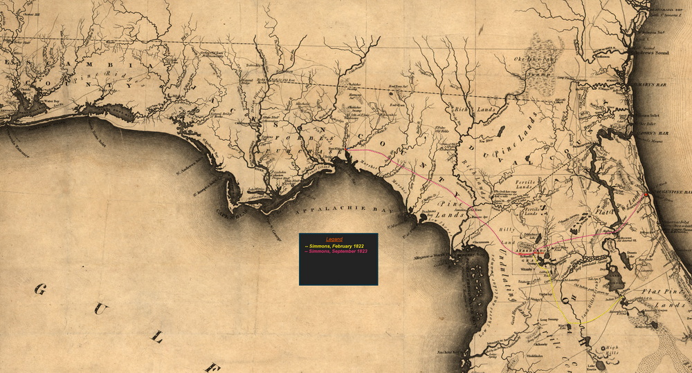
Simmons Route to Fort St. Marks
So the following year, in October of 1823, Simmons found himself again back in Wantons on his way cross land to St. Marks on the gulf, with the mission of finding a new site for the Florida government seat.
Exhausted and not feeling well from his journey from St. Augustine in the pouring rain, Simmons stayed at Wanton’s for two more days before continuing on October 1st. Simmons didn’t write much about his stay at Wantons this time, but that is not unexpected for his mission was westward and Wanton’s was just stopping point on the way. He writes, “A rainy day but there being no likelihood of better weather I set out with two guides, two pack- horses, and sufficient provisions for ten days.” Ten days provisions for three for the journey to St. Marks, some 150 miles or so, by horseback. Sounds reasonable.
Simmons decided on “what is called the middle road, which leads over the Santaffy [Santa Fe] near to its junction with the Suwannee, as I understood there was an Indian settlement there, where I could procure canoes to put me over the latter river.” The middle route goes along the south side of the Alachua Prairie then westward to just below where the Santa Fe River joins the Suwannee then westward paralleling the Gulf coast to the St. Marks at the confluence of the St. Marks river and the Wackhulla (Wakulla) River where Simmons was to meet John Lee Williams who was coming from Pensacola.
There is a northern route from Wantons that heads north then curving around the north side of the Alachua Prairie. This route would have taken Simmons by the Alachua Sink. Passing around the north-east corner of the prairie, the route then heads northwest crossing over the Santa Fe at the Natural Land Bride where the river goes underground for three miles. From the land bridge you go westward crossing the Suwannee further upstream. This route was chosen for the Bellamy Road, the first federal road in Florida.
Our road crossed the southeastern end of the great Alachua Savannah which at this time did not contain much water, and presented a beautiful expanse of fresh and living verdure. The called the Alligator Hole, at its western extremity, where the waters discharged themselves underground, I have never had an opportunity of examining, but from the testimony of the Indians and negroes it appears that the account given it by Bartram is substantially correct.
Alligator Hole or better known as the Alachua Sink on the north side of the Alachua Savana which Simmons did not see since he traveled on the south side of the Savana. Bartram who visited the Alachua Sink in 1773 and described it as,
This is the recepticale, or rather, passage of the Waters of this vast Savanah, called the Sink, & here the waters gradually descend & sink down, & are discharged by hidden, subterranian Passages no one knows where; it is the common opinion of Indians & Traders, they run into the little St Juane River that flows into the Bay of Appalatche. This Sink is the most remarkeble Place for Allegatore, & to relate the Tales & accounts given by the Indians & Traders, would appear incredible & fabulous, however to my own certain knowledge, they are prodigiously numerous & of a dredfull appearence. I saw them 20 or more together in heaps uppon one another basking in the sun on the shore round about, & the Surface of the water almost cover'd with their monstrous heads, floating about like logs or chunks of wood. [Bartram’s Travels, p149].
In Vignoles’ book he mentions the Sink but says that he had only heard stories about it but never visited it. Simmons said one of his guides said the water entering the sink made its way to the Suwannee. “On my asking him how he knew this to be the case, he said that some years ago, an Indian bathing near the sink was drowned and his body afterwards found in the Suwannee.” After traveling about twelve miles the weather became so bad that they took shelter under a “bark camp left by the Indians,” where they stayed the night.
The following day they set off westward going through rolling pine land intermixed with some oak and hickory, traveling until nine that night where the camped by a small pond where, “rained in the night and we suffered from the want of a tent. I did not bring one from the idea it would prove too heavy an addition to the baggage.”
The following morning the rain had stopped, and they broke camp at half past six then continued westward and after a two-hour ride reached the Santa Fe River where they “found it so high that we could not attempt to cross it without a boat.” If they had crossed the Santa Fe river at this point, then a few miles later they would had to cross the Suwannee River. This made some sense in that after the Santa Fe joins the Suwannee it becomes quite large so crossing two smaller rivers upstream may have been a better one big river. The level of both rivers, but particularly the Santa Fe, depends on how much rain has recently fallen. In 2012 the Santa Fe reached a flood level of 52 feet and at times has been known to flood over the Natural Land Bridge. On the other hand, in 2026 after months of extreme draught you could walk across the Santa Fe at O’Leno without getting your feet wet.
Unable to cross the Santa Fe, they headed west along the south bank of the Santa Fe where they found an Indian settlement consisting of fourteen or so houses centered around a public square and ball court. They tried to obtain canoes from the Indians which, at first they said no, but after a bribe of two dollars one agreed meet them at a better crossing point two miles downstream with a canoe. They reached the point in about an hour and the Indians with a canoe arriving soon after. It took them some time to cross, “as the river is so broad and rapid that we could not venture to swim over more than one horse at a time and we had five to cross.” With the horses fatigued from crossing the river, they proceeded more slowly and traveled only twelve miles before stopping for the night.
October 6th, After three days of slow travel due to the condition of the horses, they reached the settlement of the Indian King Higo’s Negros where they obtained corn for their horses. The Indians often had Negros, some were slaves they purchased and others run-aways from Georgia. Two days later they came to the Ausilly River (now the Econfina River) which they “formed our hide into a boat, which conveyed across our baggage, and swam over ourselves on horseback.” The “boat” was little more the cow hide stretched over a wooden frame of saplings lashed together. Not sufficient to carry a man but allowed their supplies to be ferried across the river. Upon the west side of the river Simmons describes as, “the hammock of the Miccasukies” Indians. They passed through several Indian settlements with “several luxuriant fields of corn and peas.” The Indian paths were so numerous that they became uncertain of the direction so when they came across small Indian village where they camped for the night “being promised by the people to be put on the right road in the morning.”
After two more days of travel through hammocks consisting “of the various species of oak, laurel, magnolia, bay, Spanish cedar, sassafras, dogwood, and some beech, the first I have observed in Florida,” they arrived at St. Marks on October 10th, “At sunset, arrived at the Fort, where I was hospitably received by Captain McClintock and the rest of the officers. I found that Mr. Williams, my colleague, had not arrived.“ It had taken fifteen days for Simmons to travel overland from St. Augustine to St. Marks.
Updated: 2026-08-07