


A Bit of History
1823 Vignoles Map of Florida
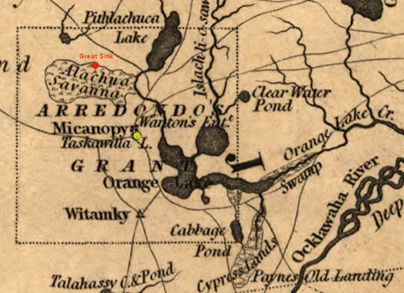
Alachua Sink in Red
Click to see larger map
In earlier times the Spanish had established a cattle ranch called La Chua on the north side of the Alachua Savana near the Great Sink but had was abandoned 1706 after repeated attacks by the British aided by the native Indians. William Bartram tells in 1774 his travels how the Seminole Indians of the time had large herds of Spanish cattle on the savanna. By the time of Vignoles expedition in 1822, the Alachua Seminoles, led by chief Micanopy, had mostly moved further south leaving only a scattered presence in the Alachua Savana area. Arrendondo, in an attempt to settle his grant, engaged Edward Wanton and Horatio Dexter to negotiate with Chief Micanopy to allow settlement in the area. Wanton succeeded and established a trading post and the settlement was named Micanopy after the chief. Both Wanton’s and Micanopy were shown on Vignoles’ map. Also in 1822, although not shown on Vignoles’ map was Moses Levy’s Jewish settlement called Pilgrimage located a few miles west of Micanopy. These were the earliest white settlements in the interior of Florida and would play an important role in the fate of the Arrendondo Grant.
From the very beginning of the U.S. obtaining Florida, the question of ownership of the Spanish land grants was questioned and challenged in courts. Most of the grants east of the St. Johns River either were not challenged or resolved quickly as they had had settlers on them for some time. The Arrendondo grant on the other hand was contested. The original grant had conditions placed upon Arrendondo, agreement from the Indians to settle and to have 200 settlers within three years. Getting the Seminoles to agree to settlement was no easy feat considering few white men dared venture west of the St. John’s River, but Wanton managed to get permission from Chief Micanopy and established his trading post and Micanopy. To increase the number of settlers, Arrendondo gave a 20,000-acre tract of land northwest of Micanopy to Moses Levy who created his settlement of Pilgrimage.
It was not until ten years later in 1832 that the U.S. Supreme court ruled that Arrendondo did indeed own the land, with the settlements of Wantons, Micanopy, and Pilgrimage a key factor in the conditions being met. Another even larger grant shown on Vignoes’ map, the Miranda’s Grant of 368,640 acres, 8x8 leagues square, in the area of Hillsborough and Tampa Bays on the Gulf, did not fare so well with the court ruling Miranda did not meet the conditions and thus the grant was void.
Updated: 08-06-2026